Upon landing in Los Angeles, I was caught by the rental car office’s TV, an LED display proudly showing its vivid red capabilities. Only this red indicated ‘red flag’ warnings. Okay, I thought, I have to go directly north from the airport, into Beverly Hills and Hollywood, and that the fire was just north and east. I didn’t think too much about it and got in my car and headed out into the beautiful sunny 70-degree day. Listening to the news, I had my first introduction to the impact the fires had with the city of Ventura Mayor just beginning his very first day in office. His first day included 1,000 firefighters in his County, over 3,000 people in shelters, and an impending disaster that he could never have predicted nor assumed taking responsibility for in his wildest dreams. That was an interesting interview, but there was much more to come.
Traveling through the heart of Los Angeles and finishing lunch, I still had no clue. Passing by ABC’s Animation Studios, Warner Bros., and the Record Plant – where so many famous vinyl records were produced in the 1970s – and impeccable cemeteries where the luminaries of Hollywood are buried, gave me no indication of what I was in the middle of as well as half a million others in the vicinity. Only seven miles away.
I was in Los Angeles as an expert witness for a fire alarm installation gone wild with one of the largest authorities in California, getting a wood-fired pizza for lunch, and in the midst of one of the largest fires California had ever seen. I still didn’t see the intersection of events.
I only realized it when I arrived at the hotel and saw a 52” television brightly lit with the same red flag warnings – after traversing only three counties at this point. The fire news was 24/7 nonstop. That night they explained how they pinpoint fire predictions to the kilometer, using a new prediction system inaugurated only two years ago. It has levels of danger which anticipate the incendiary nature of groundcover and trees, and compounds the humidity, or lack thereof, and wind, to accurately assess a metric of real-time hazardous environmental fire conditions.
It was truly startling. The inventor of the system was from one of the prediction laboratories in the area instituting the metric as a prism of colors from yellow through orange to red and finally purple, with purple being the highest level and the highest potential for catastrophe. In his live interview that night, he stated that since launch they had never had even one area in purple, but now purple stretched across multiple counties in the northern Los Angeles region.
This was absolutely shocking. This was not like snow where you’re being buried in three feet, and perhaps you can’t get your fresh milk, you might have to have canned soup for a couple of days, or you lost power and have to deal with perishables and their replacements. No, this was getting out of your home immediately, going to a shelter, and praying that you would have a home to go back to.
The predictions were dire, anticipating up to 70 mph Santa Ana winds, and a breach of fire across a major artery that spans west to east; the firefighters’ plan was to prevent the fire from jumping the highway. Their success wasn’t man-made – it was luck. Only because the wind’s capacity that night was a relatively low 35 mph, embers did jump the highway, but they were contained quickly.
Turning on my television the next morning at 5 AM gave a startling resonance to the might of fire and how quickly it consumes with the high winds. The one story that seemed to strike everyone is of horses in a barn. Laborers could not save the structure from being consumed within minutes. The catastrophic envelope killed approximately 40 horses in less than ten minutes, but three were spared.
The pictures of these poor animals were horrendous. I never realized how sensitive mucous membranes are to heat. All the horses’ lips and eyes were burnt since these have no protection. Both hair and skin provide an element of protection where mucous membranes are compromised much more quickly. It is hard to describe to you graphically what they showed visually on television, but it was certainly one the worst cases of physical harm and especially emotional trauma a horse could go through.
But there was more. The news was all about the fires, with residents having to be ready at a moment’s notice to leave, having no more than two minutes to go. And while many homes were spared, there were thousands in shelters as well as over one hundred schools closed. The transcriber in our deposition told us how it took her an extra hour driving just to get her children because of the blocked roads – the smoke’s intensity necessitating the closures.
If you think it’s difficult explaining snow to those in equatorial places, with their first thought of how beautiful it is, consider the opposite; explaining the nightmarish consequences of embers traveling up to two miles in the Santa Ana winds. These winds blow northeasterly at night after sunset at rates of up to 70 mph. The embers may engulf your home, but not your neighbors’ across the street in as little as five minutes. Or entire neighborhoods, at the whim of heat, wind, and the dryness of the environment – not having had rain of any measurable amount since March 2017. And that’s with the drought officially over. But it’s the remnants of the years of drought that create this environmental calamity.
So, think of how your heart would feel at the loss of your home and every possession which would be consumed like a smith’s casting fire, with everything incinerated by the wind’s forces increasing consumption temperatures above 900°F. And when it catches, there’s no intumescent roof coating, asbestos-like protection, time to get the fire department or, in most cases, enough water pressure to be used by the homeowner. The embers blow under your car, into your shrubs, up under eaves and onto your porch, leaving no quarter untouched by the fast spreading wind-blown heat.
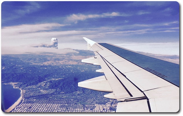
The photo is of my trip back to Philadelphia out the aircraft window, showing two areas of burning that can be seen. Air traffic control required the plane to go out to sea, directly out into the Pacific for what seemed like a trip to Hawaii. Upon returning to land I was offered a birds-eye seat, the one I paid for. The farthest fire, the one with the chimney-like effluence, is the Thomas or Ventura County Fire, while the lower one is, I believe, the Skirball Fire. You can see how the winds are blowing to the west which is what is desirable. If they blew to the east or northeast this would be the Santa Ana winds and be stronger and cause more damage.
It is hard to put yourself in this position. It was remarkable being in this area at that time, forever having compassion and outreach for those having been affected. The response by locals was overwhelming with people driving everything from water to food to diapers to the centers helping those in need.
Flying back and seeing only thirty second sound bites, I knew it was important to drive this information home so that we can all understand the severity of these situations. With only one firefighter loss out of thousands rotating in and out, this is a massive command effort with verifiable acknowledgment of the safety of those who battle by hand fire’s danger, under the supervision of skilled chiefs and managers.
My prayers are with all affected, especially those providing almost super-human energy in order to protect life and others’ properties under the most difficult, mountain steep, ground access conditions.

